Investigation of NavIC and GPS Multipath Phase for Soil Moisture Studies
Sushant Shekhar*, Rishi Prakash and Anurag Vidyarthi
Department of Electronics and Communication Engineering, Graphic Era Deemed to be University, Dehradun, India
E-mail: sushantshekhar09@gmail.com
*Corresponding Author
Received 28 January 2021; Accepted 10 June 2021; Publication 29 June 2021
Abstract
This paper aims to investigate the relationship between the multipath phase of Global Navigation Satellite System (GNSS) and volumetric moisture content (VMC) of soil. The carrier to noise ratio (C/No) data of multipath signals at two different frequencies has been analyzed. The first one is India’s NavIC L5 frequency (1176 MHz) and the second one is GPS L1 frequency (1575 MHz). The received multipath signals are highly dependent on dielectric value of soil and the elevation angle of satellite. The relationship drawn for the NavIC and GPS C/No data is based on multipath phase analysis and in situ soil moisture. The values of correlation coefficient observed between these parameters were 0.9 and 0.63 for NavIC and GPS multipath signal respectively. The result from both GNSS shows good sensitivity and could be used to estimate the soil moisture for agricultural land.
Keywords: Multipath phase, GNSS, GPS, NavIC, soil moisture.
1 Introduction
Soil moisture is an essential parameter to study in different fields such as hydrological cycle, biochemical process, vegetation, soil erosion, reservoir management, flood monitoring and several others. Soil moisture monitoring with the help of remote sensing is filled with several challenges (Katzberg et al., 2006). There are various satellite derived products available in order to monitor soil moisture. International soil moisture network, SMAP (Soil moisture active and passive) mission of NASA, Committee on Earth Observation satellites (CEOS) are some of those. Ground truth validation is always required for these products as they cover large area and compromised with several local factors. GNSS Interferometry based on multipath signal could be used as a solution to retrieve soil moisture of an agricultural land. Number of studies has been carried out which uses multipath signal to monitor soil moisture (El Hajj et al., 2019; Eroglu et al., 2019). The interference pattern of direct and reflected signal received by ground based antenna majorly depends on surface property, elevation angle of satellite, and antenna height from surface (Calabia et al., 2020; Rodriguez-Alvarez et al., 2011; Zavorotny et al., 2010). Zhang et al. (2017) proposed an algorithm based on the multipath phase to estimate soil moisture. They analyze the multipath phase by considering the average of phases traced from different satellite tracks (66 per day). In other paper, Han et al. (Han et al., 2018) derive an empirical relationship between soil moisture and multipath amplitude and phase. Yang et al. (Yang et al., 2017) compared the estimated relative permittivity of soil surface with multipath phase for GPS (Global positioning system) and BDS (Beidou Navigation Satellite System). Larson et al. (Larson et al., 2015) applied least square estimation technique to determine multipath phase that was used in estimation of soil moisture based on multipath SNR (Signal to noise ratio) data.
In the present work C/N data of multipath signal is considered because C/N values are independent of the tracking algorithm used by the receiver as well as completely independent of the front end bandwidth of receiver. The paper provides the relationship of multipath phase with soil moisture at two different frequencies (L1 and L5) of different navigation satellite system (i.e., GPS and NavIC).
These two satellite systems are unique in different aspects but both of them gives almost similar relationship for VMC of soil and multipath phase. India’s NavIC constellation have 7 satellites in Geo orbit at height of 36000 km operating at dual frequency L5 (1176.45 MHz) and S1 (2492.09 MHz). Whereas, GPS circles the Earth at an altitude of about 20,000 km at 1575.42 MHz (L1) and 1227.60 MHz (L2). Range of elevation angles considered for soil moisture studies with GPS L1 is from almost 5 to 30 (Chew et al., 2016; Larson et al., 2010; Wan et al., 2015). However, the variations of elevation angle to determine the phase of NavIC multipath signal is 15 to 30 (Chamoli et al., 2020; Shekhar et al., 2020). It was noticed during observation that time taken by NavIC satellites to complete the required elevation range is almost double of the GPS satellites.
2 Experimental Site
The multipath data has been collected by NavIC/GPS/SBAS (NGS) receiver using single ground based antenna at a height of 2.16 m above the soil surface as shown in Figure 3. The receiver used for observations is developed by Accord software and system Pvt. Ltd. Bangalore. The observations were taken and analyzed continuously for 30 days. The experimental site is situated at an agricultural field (longitude: 78.007E, latitude: 30.288N) in Dehradun as shown in Figure 1.
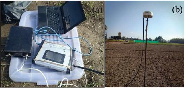
Figure 1 (a) Setup for receiver. (b) Antenna fixed at 2.16 meter above the ground surface.
The range of satellite elevation angle to collect raw C/N data carried out for soil moisture studies with GPS L1 is 5 to 30 and for NavIC multipath signal is 15 to 30 (Chamoli et al., 2018, 2020). The in situ soil moisture was collected with soil moisture probe from the first Fresnel zone of reflection, which is almost about 10 m as shown in Figure 1 (Katzberg et al., 2006). 18 in situ soil moisture samples were collected and average of these samples were used to calibrate the multipath phase for L-band signal of NavIC and GPS. The soil moisture probe used in this work (Mpm-160-B) was developed by ICT international Pvt. Ltd. As the range of RMS height observed is between 0.69 cm and 0.81 cm, the surface roughness has been classified as smooth according to Fraunhofer criteria for microwave frequencies.
3 Methodology
Figure 2, shows the geometry of the multipath signal received by the GNSS antenna kept at a height ‘’ from the soil surface. When a signal reaches the destination through more than a single path it is referred to as multipath. In GNSS interferometry, the ground-based antenna receives the signal through dual path, i.e., reflected plus direct path as shown in Figure 2.
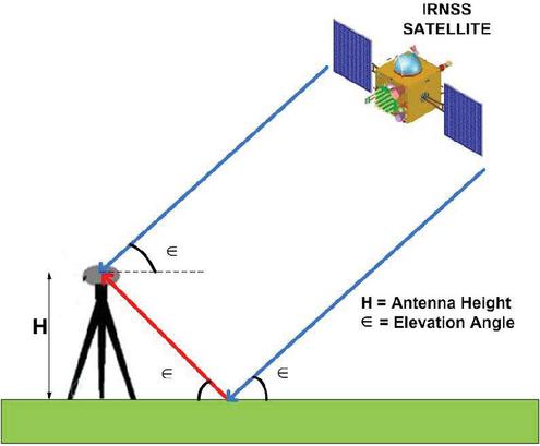
Figure 2 The receiver receives a Multipath signal.
The interference pattern of the received multipath signal depends on the soil moisture condition. In several studies, it has been stated that the penetration depth of the signal depends on the soil moisture of the land cover. As the dielectric value of soil increases, the value of penetration depth for satellite signal decreases. The relative height of the antenna changes with the change in the penetration depth of the signal. The value of the relative height of the antenna is the height of the antenna from the point of reflection inside the soil surface. The value of path difference of the reflected signal () depends on the value of relative antenna height (H) above soil surface and satellite elevation given by following equation (Zhang et al., 2017).
| (1) |
As the properties of reflected signal changes with the change in penetration of the reflected signal, the generated interference pattern of multipath signal also changes. The value of C/N data received by the NGS (NavIC/GAGAN/SBAS) receiver associated with the variations in reflected signal also changes. It was observed that the obtained interference pattern of the multipath signal is sinusoidal in nature. The sinusoidal interference pattern of multipath signal received at the receiver depends on the surface characteristics. The sinusoidal behavior of received C/N multipath data can be characterized on the basis multipath phase, amplitude and frequency as given by equation 2 (Shekhar et al., 2020; Wan et al., 2015; Zavorotny et al., 2010; Zhang et al., 2017).
| (2) |
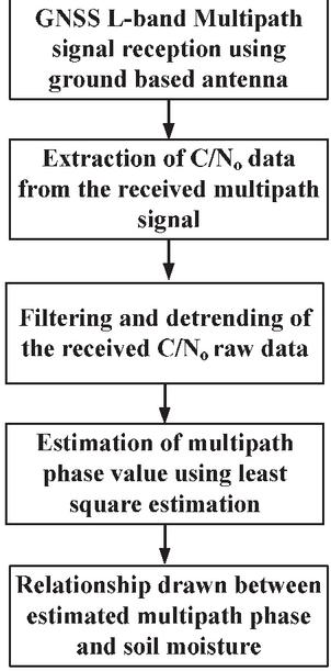
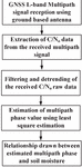
Figure 3 Flowchart to observe the multipath phase and soil moisture correlation.
and are amplitude and phase (in radian) of interference pattern generated due to variations in received C/N data respectively. With the variations in received C/N data, the value of multipath amplitude and phase changes. To perform the sensitivity analysis, the received interference pattern is required to be processed for the estimation of change in the value of the multipath phase. The basic steps involved to perform further analysis on the multipath signal to calculate the correlation coefficient are shown in Figure 3. The received multipath signal comprises of several high frequencies noise and need to be filtered for further processing. The filtered multipath signal is detrended to remove all the DC values present in it. Further, filtered and detrended multipath data is sine fitted using the least square estimation technique. The value of the multipath phase is evaluated from the sine fitted curve to correlate it with the in situ soil moisture.
4 Results and Discussion
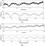
The C/N data was collected for both L1 (GPS) and L5 (NavIC) frequencies for the required satellite elevation angle range, i.e., 15 to 30. Both navigation systems show good sinusoidal interference patterns for the selected range of satellite elevation angles. The received multipath signals are sinusoidal and contains several high frequencies noise signals. The analysis of this multipath signal is required to be done for estimating the multipath phase of the received signal. The received C/N data are in the unit of dB/Hz and converted in terms of power units for further processing as shown in Figure 4. To analyze the multipath signal, the filtering of the noise was required by using low pass filter. Further, the filtered C/N data are detrended to zero level for removing all aspect of DC value available in the received multipath signal.
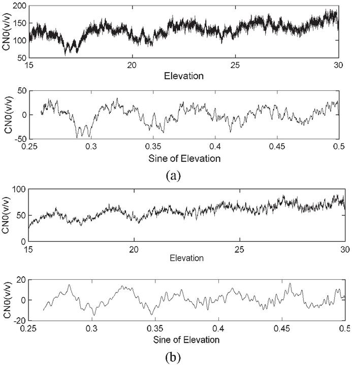
Figure 4 (a) Raw data received by NGS receiver for NavIC (Upper portion) & detrended and Filtered Data for NavIC (Lower portion). (b) Raw data received by NGS receiver for GPS (Upper portion) & detrended and Filtered Data for GPS (Lower portion).
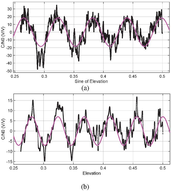
Figure 5 (a) Data fitted for NavIC L5 with Sine curve Multipath Phase 0.6102 radian. (b) Data fitted for GPS L1 with Sine curve Multipath Phase 0.2781 radian.
In this work, least square estimation technique is used to estimate the required curve fit on detrended data to investigate the multipath phase from the sinusoidal interference pattern. The retrieved multipath phase is one of the parameters that gets affected because of soil moisture variations and depends on the penetration depth of the signal as discussed earlier. The curve fitted data by utilizing least square estimation is shown in Figure 5.
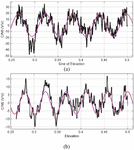
It has been observed from Figure 6, that C/N multipath data collected for both L1 (GPS) and L5 (NavIC) frequencies are sinusoidal and an extra crest for GPS is observed for the same satellite elevation range. A similar analysis has been carried out to estimate the multipath phase for all the respective samples of in situ soil moisture. Further, the obtained multipath phase values were correlated with the in situ volumetric content of the soil to perform the sensitivity analysis of the multipath signal for the soil moisture estimation. The total number of GPS samples shown in Figure 6 is more comparable to NavIC, as the C/N multipath data collected for the GPS is from more than one satellite over the required time duration within the required elevation angle range. A linear relationship is observed between soil moisture and multipath phase of both GPS and NavIC signal which has been shown in Figure 6. The statistical measurement of the relationship between in situ volumetric content of the soil and multipath phase value is carried out with correlation coefficient.
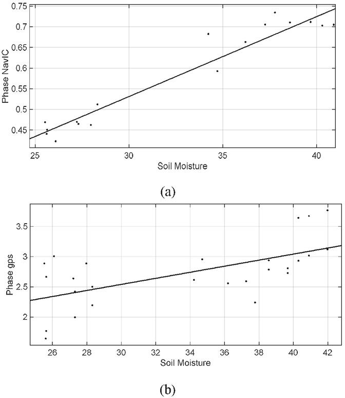
Figure 6 Relationship obtained between volumetric moisture content of soil and multipath phase. (a) For NavIC. (b) For GPS.
The multipath phase values ranges from 0.36 to 0.72 radian and 1.98 to 3.6 radian for NavIC’s L5 and GPS L1 frequencies respectively. Whereas, in situ measured volumetric soil moisture content varies from 21.3% to 42%. The value of correlation coefficient observed for NavIC’s L5 and GPS L1 frequencies are 0.9 and 0.63 respectively. The obtained results are good and overwhelming which can be further used in estimation of soil moisture using GNSS signal.
5 Conclusion
In the past few years, soil moisture analysis with the GNSS signal has gotten a lot of attention from researchers. For the sensitivity analysis of soil moisture, the received C/N multipath data were analyzed for two frequencies are L1 (GPS) and L5 (NavIC). The multipath signals observed are sinusoidal in nature. This sinusoidal behavior of the multipath signal depends on the volumetric moisture content of the soil. The property of the reflected signal changes as per the dielectric behavior of the soil depending on the penetration depth of the signal on the soil surface. Further, to carry out the sensitivity analysis, the obtained multipath signal phase was evaluated and correlated with their respective in situ soil moisture. The study carried out shows good correlation coefficient of 0.9 and 0.63 between in situ measured volumetric moisture content of soil and the NavIC L5 and GPS L1 frequencies. The results demonstrate that both GPS and NavIC signals show similar behavior to soil moisture variations and can also be used to estimate soil moisture.
Acknowledgement
This paper’s authors extend honest heartfelt gratitude to SAC Space Applications Centre (SAC), Indian Space Research Organization (ISRO), Ahmedabad, for providing all the economic help and experimental arrangements required to accomplish out the sensitivity analysis.
References
Calabia, A., Molina, I., & Jin, S. (2020). Soil Moisture Content from GNSS reflectometry using dielectric permittivity from fresnel reflection coefficients. Remote Sensing, 12(1). https://doi.org/10.3390/RS12010122
Chamoli, V., Prakash, R., Vidyarthi, A., & Ray, A. (2018). Sensitivity of NavIC signal for soil moisture variation. 2017 International Conference on Emerging Trends in Computing and Communication Technologies, ICETCCT 2017, 2018–January, 1–4. https://doi.org/10.1109/ICETCCT.2017.8280318
Chamoli, V., Prakash, R., Vidyarthi, A., & Ray, A. (2020). Capability of NavIC, an Indian GNSS Constellation, for Retrieval of Surface Soil Moisture. Progress in Electromagnetic Research, 106(November), 255–270.
Chew, C., Small, E. E., & Larson, K. M. (2016). An algorithm for soil moisture estimation using GPS-interferometric reflectometry for bare and vegetated soil. GPS Solutions, 20(3), 525–537. https://doi.org/10.1007/s10291-015-0462-4
El Hajj, M., Baghdadi, N., Bazzi, H., & Zribi, M. (2019). Penetration analysis of SAR signals in the C and L bands for wheat, maize, and grasslands. Remote Sensing, 11(1), 22–24. https://doi.org/10.3390/rs11010031
Eroglu, O., Kurum, M., & Ball, J. (2019). Response of GNSS-R on Dynamic Vegetated Terrain Conditions. IEEE Journal of Selected Topics in Applied Earth Observations and Remote Sensing, 12(5), 1599–1611. https://doi.org/10.1109/JSTARS.2019.2910565
Han, M., Zhu, Y., Yang, D., Hong, X., & Song, S. (2018). A semi-empirical SNR model for soil moisture retrieval using GNSS SNR data. Remote Sensing, 10(2), 1–19. https://doi.org/10.3390/rs10020280
Katzberg, S. J., Torres, O., Grant, M. S., & Masters, D. (2006). Utilizing calibrated GPS reflected signals to estimate soil reflectivity and dielectric constant: Results from SMEX02. Remote Sensing of Environment, 100(1), 17–28. https://doi.org/10.1016/j.rse.2005.09.015
Larson, K. M., Braun, J. J., Small, E. E., Zavorotny, V. U., Gutmann, E. D., & Bilich, A. L. (2010). GPS Multipath and Its Relation to Near-Surface Soil Moisture Content. IEEE Journal of Selected Topics in Applied Earth Observations and Remote Sensing, 3(1), 91–99. https://doi.org/10.1109/JSTARS.2009.2033612
Rodriguez-Alvarez, N., Bosch-Lluis, X., Camps, A., Aguasca, A., Vall-Llossera, M., Valencia, E., Ramos-Perez, I., & Park, H. (2011). Review of crop growth and soil moisture monitoring from a ground-based instrument implementing the Interference Pattern GNSS-R Technique. Radio Science, 46(5), 1–11. https://doi.org/10.1029/2011RS004680
Shekhar, S., Prakash, R., Vidyarthi, A., & Pandey, D. K. (2020). Sensitivity Analysis of Navigation with Indian Constellation (NavIC) Derived Multipath Phase towards Surface Soil Moisture over Agricultural Land. 2020 6th International Conference on Signal Processing and Communication, ICSC 2020, 138–142. https://doi.org/10.1109/ICSC48311.2020.9182714
Wan, W., Larson, K. M., Small, E. E., Chew, C. C., & Braun, J. J. (2015). Using geodetic GPS receivers to measure vegetation water content. GPS Solutions, 19(2), 237–248. https://doi.org/10.1007/s10291-014-0383-7
Yang, T., Wan, W., Chen, X., Chu, T., & Hong, Y. (2017). Using BDS SNR observations to measure near-surface soil moisture fluctuations: Results from low vegetated surface. IEEE Geoscience and Remote Sensing Letters, 14(8), 1308–1312. https://doi.org/10.1109/LGRS.2017.2710083
Zavorotny, V. U., Larson, K. M., Braun, J. J., Small, E. E., Gutmann, E. D., & Bilich, A. L. (2010). A Physical Model for GPS Multipath Caused by Land Reflections: Toward Bare Soil Moisture Retrievals. IEEE Journal of Selected Topics in Applied Earth Observations and Remote Sensing, 3(1), 100–110. https://doi.org/10.1109/JSTARS.2009.2033608
Zhang, S., Roussel, N., Boniface, K., Cuong Ha, M., Frappart, F., Darrozes, J., Baup, F., & Calvet, J. C. (2017). Use of reflected GNSS SNR data to retrieve either soil moisture or vegetation height from a wheat crop. Hydrology and Earth System Sciences, 21(9), 4767–4784. https://doi.org/10.5194/hess-21-4767-2017
Zhang, S., Roussel, N., Boniface, K., Ha, M. C., Frappart, F., Darrozes, J., Baup, F., & Calvet, J.-C. (2017). Use of GNSS SNR data to retrieve soil moisture and vegetation variables over a wheat crop. Hydrology and Earth System Sciences Discussions, March, 1–26. https://doi.org/10.5194/hess-2017-152
Biographies

Sushant Shekhar is working as a Senior Research Fellow at the Propagation Research Lab of the Electronics & Communication Engineering Dept., Graphic Era Deemed to be university in a project funded by Space Applications Centre (SAC), Indian Space Research Organization (ISRO), Ahmedabad. He has got around 6 years of experience in academics and industry. He has completed his M.Tech from JIIT Noida, India in 2016 and currently perusing his PhD from Graphic Era Deemed to be university. He has authored and co-authored several research papers in SCI/SCOPUS/Peer Reviewed Journals and IEEE/Springer Conference proceedings. He is the member of IEEE and worked as a TPC member for various reputed conferences. He has multi-discipline/cross disciplined ability in field of teaching and research.

Rishi Prakash did his Ph.D. from Dept. of ECE, IIT Roorkee. Currently he is serving as Associate Professor in Dept of ECE, GEU, Dehradun, India. His research interests are soil parameter retrieval with microwave remote sensing. He has published many research papers in this field. Currently he is working on non-navigational applications of GNSS. He is closely associated with Indian Space Research Organization for developing soil moisture retrieval model with NavIC constellation under different field conditions.

Anurag Vidyarthi obtained B.Sc. degree from MJPR University, Bareilly, India, in 2005 and M.Sc. degree from BU Bhopal, India, in 2007. He receives M.Tech. and Ph.D. degree from Graphic Era University, India, in 2010 and 2014 respectively. Presently he is associated with Department of Electronics and Communication Engineering, Graphic Era University, Dehradun, India. His areas of interest are rain attenuation, fade mitigation techniques, ionospheric effects on the navigation system, and applications of Navigational satellite data.
Journal of Graphic Era University, Vol. 9_2, 183–194.
doi: 10.13052/jgeu0975-1416.925
© 2021 River Publishers