Point Measurement Techniques and Radar Remote Sensing Technique Using for Soil Moisture Estimation: A Literature Review
Vivek Chamoli*, Rishi Prakash and Anurag Vidyarthi
Department of Electronics & Communication Engineering, Graphic Era Deemed to be University, Dehradun, Uttarakhand, India
E-mail: vivekchamoli08@gmail.com; Rishi.prakas@gmail.com; vidyarthianurag@yahoo.co.in
*Corresponding Author
Received 03 January 2021; Accepted 11 May 2021; Publication 29 June 2021
Abstract
In spite of the fact that previous researchers have utilized different systems of moisture content assurance of soils. In this specific situation, analysts have built up a few systems for estimating the soil moisture eg., thermo gravimetric, neutron dissipating, soil resistivity, dielectric methods and Radar Remote Sensing method using SAR (Synthetic-aperture radar) images. Be that as it may, these methods are very mind boggling, costly (because of very intricate hardware and gear) and henceforth past the span of many. This audit accentuates that why it winds up basic to assess different techniques utilized by the analysts for assurance of the soil moisture. Likewise, a necessity for finding new soil moisture estimation methods or altering the current strategies has been surveyed.
Keywords: Dielectric techniques, frequency domain reflectometry, neutron scattering, soil moisture, thermo gravimetric, time domain reflectometry, synthetic-aperture radar (SAR).
1 Introduction
In comparison to the overall amount of water available across the world, soil moisture is the temporary accumulation of water within a shallow layer of the earth’s upper surface [1, 2]. Recent developments in new technologies have opened new exciting opportunities for scientists and researchers to understand and address current challenging issues such as climate change, global warming, environment, weather and sustainability. To monitor the Earth’s surface characteristics, particularly, soil moisture [3–8], many ground-based, air based and space based experiments have been performed since four decades and significant results have been achieved. From the perspectives of climate change, weather monitoring, soil moisture modeling, soil erosion, integrated sensing of soil moisture and the evaluation of moisture content in the soil is a significant field of research [9–19]. In agriculture perspective, soil moisture statistics is crucial for many areas like improving crop yield, water system planning and plant stress using different sensor and techniques [20–26]. Soil moisture also defines the distribution of net radiation in the field of meteorology into latent and sensitive heat components. Accurate soil moisture estimates are therefore crucial, for many purposes, to investigate the impact of the climate change on land surface and to measure the amount and variability of regional water supplies on such as, soil moisture, infiltration flows, runoffs or surface temperatures induced by change in heat flows. So there is need of techniques or sensors from which soil moisture can be retrieved.
2 Soil Moisture Point Measurement Techniques
The direct measurement by analyzing soil sample under laboratory condition is known as the point measurement or in situ method. This technique is further classified as (i) Standard soil moisture measuring techniques and (ii) Non-Standard soil moisture measuring techniques.
2.1 Standard Soil Moisture Measuring Techniques
In traditional estimating systems, soil moisture is assessed by chemical response or evaporation of the sample soil and evacuating the moisture.
(i) Oven-drying technique:
The oven-drying approach is normally used to estimate the content of soil moisture and has been used as the standard approach for comparing soil moisture content [4, 13]. This procedure incorporates taking a soil test from the field and choosing the weight of water contained in a soil test, in regard to the weight of dry soil. To decide the soil moisture content first the weight of wet soil test was estimated and after that it was kept in oven at 105 Celsius for 24 hours to make the sample moisture free [27–30].
The gravimetric soil moisture was assessed as
| (1) |
The volumetric soil moisture was assessed as
| (2) |
where Hm weight of moist soil, Hd is is weight of dry soil and is soil bulk density.
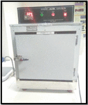
Figure 1 Hot Air Convection Oven (HA-CO).
Figure 1 shows the Hot Air Convection Oven used in Oven-drying technique. The main advantage of this strategy is that it requires generally basic, economical hardware, and one labor. Then again, the primary inconvenience of this technique is that it requires a lot of physical exertion and time, to gather dry examples, and figure moisture rate. It takes least 24 hours to touch base at the soil moisture estimation.
2.2 Non-Standard Soil Moisture Measuring Techniques
Soil moisture is measured incorporating soil electrical properties including dielectric constant, soil resistivity in modern soil moisture measurement techniques. The following are some non-standard techniques for determining soil moisture.
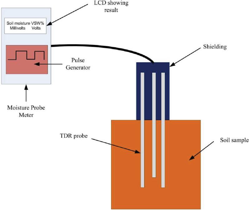
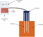
Figure 2 TDR probe soil moisture meter.
(i) Time Domain Reflectometry (TDR):
Time domain reflectometry depends on the standard of the dielectric constant of water which is a lot bigger than that of other issue, for example, soil, solid and air. The dielectric constant of water is 80 when contrasted with other matter, solid (3–8) and air (1) [31–33]. It is an electromagnetic technique which is utilized in soil moisture estimation. This technique applies a voltage signal from the pulse generator to transmission line embedded into the soil as shown in Figure 2. The voltage signal expects time to make a travel from source as far as possible of the transmission line and back once more. The TDR instrument tests the arrival signal and changes over the time estimation to length unit by utilizing the relative propagation speed (vs) from the travel-time (tt) and the length (lh) of the test, which has been gone along twice, the spread speed vs=2lh/tt is determined. The speed of pulse changes due to in change soil moisture or dielectric properties [34–38]. Figure 2 shows the Time Domain Reflectometry moisture probe meter. The benefit of this strategy is that it permits reliable estimation of volumetric water substance to be set aside a few minutes. The drawback of this strategy is that it is moderately costly hardware because of complex gadgets (electronics) and possibly appropriate under an exceedingly saline condition or in very conductive earth soils. Also, it requires soil-explicit calibration for soils having a lot of bound water (i.e., those with high natural issue content, volcanic soils, and so on).
(ii) Frequency Domain Reflectometry Technique (FDR):
FDR’s working theory is the same as TDR observations, yet as opposed to estimating the time they measure the adjustment in recurrence of transmitted signal, which is modified by permittivity/soil moisture of the ground. Frequency domain reflectometry provides an estimation of soil moisture with a change in the frequency of a signal as a result of dielectric properties. The electrical capacitance of a capacitor that utilizes the soil as a dielectric relies upon the dielectric content. At the point when this capacitor is associated with an oscillator, framing an electrical circuit, change in soil moisture can be estimated by changes in the circuit working frequency [39]. The main advantage of this technique is that it gives precise estimation, after soil explicit calibration, and it can peruse in high saltiness level, where TDR fizzles. Besides, the FDR gives preferable goals over TDR. Then again, the inconvenience of this strategy is that the detecting authoritative reach is moderately little (around 4 cm) and for precise estimations, it is incredibly basic to have great contact between the sensor and soil. Besides, this procedure is exceedingly delicate (sensitive) to temperature, clay content, and bulk density than TDR and requires soil specific calibration. Figure 3 shows the Frequency Domain Reflectometry soil moisture probe.
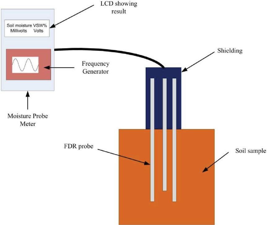
Figure 3 FDR sensor probe soil moisture meter.
(iii) Neutron Methods:
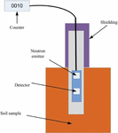
The neutron technique for estimating soil-water substance is a non-dangerous field strategy dependent on the backing off by the water of quick neutrons discharged by a radioactive source. The real estimation is generally made by bringing down a test comprising of the source and an indicator to the required profundity in the appropriate access gap in the ground. It is an exceptionally fast soil moisture estimation system having reaction time of 1–2 min [40–48]. This strategy offers the upside of estimating an enormous soil volume and furthermore the plausibility of filtering at a few profundities to acquire a profile of moisture circulation. The weakness is the high beginning expense of the instrument and radioactive materials are hurtful to living and confinements on the utilization of radioactive material are progressively in adaptable and have made this gadget less alluring for deciding soil moisture. Figure 4 show the Neutron probe soil moisture meter.
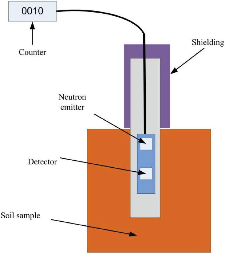
Figure 4 Neutron probe soil moisture meter.
(iv) Gamma Attenuation:
The gamma beam weakening strategy is a non-dangerous method in which there is no need of direct contact between the material under examination and locator get together. It is equipped for deciding the moisture content in the upper layer soil layer (up to 1–2 cm) and gives quick, non- destructive methods for estimating soil mass thickness and soil-water content. The gamma beam attenuation strategy is the most solid technique for deciding thickness without aggravating the soil mass [49–51].
The benefit of this strategy is that it is equipped for giving the normal water content to the profile depth. Also, the technique grants investigation of the profile by test development of estimating gadget inside the cylinder. Disadvantages of this strategy are that various soils give a similar calibration bend (curve) and gamma attenuation technique’s operating cost is relatively high.
(v) Resistive Sensor (Gypsum):
Porous Square (block) of gypsum is utilized in a standout amongst the most widely recognized dielectric constant systems utilized for estimating soil moisture in the field. Gypsum square is an electrochemical cell with an immersed solution of calcium sulfate filling in as an electrolyte, set at root zone depth. The obstruction is controlled by applying a little air conditioning voltage between the square inserted terminals utilizing a Wheatstone bridge. Since the perusing can be influenced by electric conductivity of soil, gypsum is utilized as a support against changes in soil saltiness. The gypsum squares retain all moisture from the soil, and the electrical conductance is estimated by terminals, which increments with the moisture in squares. These watched qualities are utilized to gauge the soil metric potential and soil moisture content. The main advantage of this technique is that it is simple, economical with least support and permits the estimation of soil moisture in a similar area in the field over an all-inclusive period. The disadvantage of this technique is that each Porous square framework has various qualities and each square should be exclusively aligned and instrument calibration changes step by step with time, constraining the life of porous square [52–53].
3 Soil Moisture Estimation Using Active Microwave Sensing Using SAR Images
Remote sensing has shown a great potential for estimation of surface soil moisture with both active and passive sensor sensors [54–58]. Recently, the remote sensing community has favored active microwave remote sensing systems, mainly because of the sensitiveness of SAR to the surface moisture of the ground and the availability of high spatial- and time-resolution SAR data [59, 60]. SARs have been a priority in recent years. In particular, SAR data are available at 20m nominal room resolution for 3–12 days for different regions, in particular the satellite project Sentinel 1A & B [61]. However, retrieval of the soil’s humidity with SAR signals is heavily overloaded, and this affects SAR’s backscattered signal behavior [62, 63]. In order to obtain maximum sensitivity of SAR data from soil moisture, the impact of these parameters must subsequently be removed or minimized [64–67]. Several models have been developed to retrieval the soil moisture from bare lands, such as statistics such as the Oh [68–70] and Dubois [71], the physical (IEM) [72] and the advanced IEM [73] models, and Empirical model Baghdadis [74].
Followings are brief literature about Active microwave sensing using SAR data used to determine soil moisture.
In order to quantify surface roughness, Oh et al. [68] developed an empirical model for soil moisture retrieval using multi polarized radar signals (HH, VV, HV and VH, etc.), and sought to determine the extended validity of the KA (Kirchoff model) and SPM (Small perturbation model). The main problem with the Oh model is that its length (L) and r.m.s height is highly sensitive for the surface roughness. It will also be done to reduce the roughness of the surface impact.
Dubois et al. [71] developed a remote sensed scatterometer data analytical algorithm to obtain soil humidity and r.m. The algorithm for bare surfaces was optimised and built with frequency data ranging from 1.5 (Ţ 0.205 m) to 11 GHz ( m), rugging between 0 and 0.03 m and incidence angles ranging from 30 to 40 degrees. The results shown in this paper show that soil moisture with multi-polarisation SAR can be measured from space. While only uncovered, slightly vegetated areas are covered by the existing algorithm, the work continues to broaden the algorithm to more vegetable regions.
Oh et al. [70] developed a simple invertion technique using a half empirical polarimetric disperse model for recovery from multi-polarized radar measurements of the rms surface height and moisture content. Future work will concentrate on taking vegetation and roughness into account in the model development.
For soil moisture estimates, Srivastava et al. [75] have used RADARSAT-1 SAR data. The effect of soil texture is included in the soil moisture recovery model by the authors. The information on soil moisture available to plants in terms of water is also a more meaningful input in many fields of research, especially in agriculture. Further analysis will be undertaken with regard to the roughness of the soil and its effect on the estimate of soil moisture.
In order to recover the humidity of SAR and optical data, Prakash et al. [76] proposed a fusion method. The authors have used PALSAR (Phased Array Synthetic Aperture Radar type) and MODIS data to develop an algorithm for soil moisture recuperation in covered area. The relationship is established with bare soil scattering in HH and VV polarizations and these values were used in the Dubois model, which has been co-polarized with soil moisture content regardless of roughness value.
The radar sensitivity to soil moisture and the monitoring of irrigation are investigated in Hajji et al. [77]. The SAR X-band signal on gravity irrigated grasslands was analysed in this analysis. This has shown that the radar signal of the X-band penetrates the vegetation cover ( crop height 1 m ) and enables irrigation to be tracked. However, no algorithms are provided so that a soil moisture estimation algorithm with SAR X-band can be created in future work.
The potential of S-band SAR in the soil moister in bare or poorly vegetated areas is being investigated by Guida et al. [78]. The integrated equation model (IEM) was considered an appropriate technique for both S-Band and X-Band frequency reversals through the Artificial Neural Network (ANN). The retrieval of S-band data is more precise with an average failure of less than 4% compared to X-band. We can use the same analysis for future work on drylands, so that S-band efficiency can be investigated even for extremely low soil moisture values.
The algorithm for soil moisture recuperation using L- band radar data was proposed for Narvekar et al. [79]. The algorithm introduced in this paper was designed to retrieve surface ground humidity without any additional vegetation and ruggedness information, two crucial and problematic effects on radar back dispersion. The Radar Vegetation Index and the newly introduced Radar Roughness Index (RRIP) account for modulation because of soil surface ruggedness and overlying vegetation dispersion effects between end-members (smooth naked soil, rough soil, maximum cover). The retrieval algorithm built here is not therefore based on knowledge about ancillary vegetation or ruggedness.
For agricultural regions that use the GF-3 satellite and Landsat-8 data based on the ANN process, Meng et al. [80] proposed a soil moisture recovery algorithm. Water cloud (WCM) model was used to remove the backscattering scattering from vegetation. To validate the SMC estimation algorithm, which produced satisfactory results (RMSE 0.04 & R), acquired GF–3 soil backscattering coefficients and in situ data have been used. Further analysis should concentrate on validating the proposed soil humidity recovery algorithm by field soil humidity measurements under various soil cover-type circumstances with less insecurity.
The technique for soil water and irrigation, based on the synergistic analysis of the SAR data, on soil moisture and watering at the agricultural level, has been proposed in the Bousbih et al. [81]. A classification algorithm was proposed by the Author for mapping irrigated and rainfed areas across the Cairouan Plain. Vector supporting machine used for distinguishing these two regions. If the soil moisture parameters are only used in the Decision Tree classification, the highest total accuracy (77 percent) is achieved. If the mean NDVI values are only applied, the lowest accuracy is achieved.
The unattended approach for the detection of anomalies in surfaces has been implemented by Zhu et al. [82] as a pre-compliance with SAR images of the time series for moisture recovery in soil. In short, according to the effects of change detection, time series data is divided into several sub-series. A Synthetic Data Set evaluation showed that the approach proposed would largely eliminate error causing abrupt roughness and vegetation changes in the multi-temporal soil moisture recovery. A supervised method will be developed for the future work in order to detect more precision.
Tao et al. [83] using RADARSAT-2 multi-time data for the updated model of backdispersion of vegetationThe benefit of optical and radar methods was combined by considering the diffusion of the underlying bare soil and vegetation canopy. Structural coefficient parameters that are of major significance for the updated model directly depend on surface rugging parameters. Structural coefficients were unknown in this article. Need to work to reduce uncertainties by working on exact values of ruggedness parameters.
Ayehu et al. (2020) [84] examine the potential of sentinel 1 sensor products and soil ruggedness parameters in the Upper Blue Nile (UBN) basin of Ethiopia for volumetric residual soil moisture (RSM). The contribution from crop residue was calculated with the Landsat sensor product and water cloud model (WCM). The findings demonstrated that the ANN soil humidity estimation model was fairly effective for estimating RSM using only the individual SAR VV data input variable. When SAR VV and the roughness of the surface parameters (stretches and leff) were added in the prediction model, ANN prediction accuracy was slightly improved. Future research should concentrate on validating the output in various climates and terrain use and land cover conditions of the proposed prediction of soil humidity and of the roughness estimation models using a wide variety of information
4 Conclusion
From the literature survey we have been found that thermo-gravimetric method was a traditional way and most accurate method to estimate the soil moisture, but due to time consuming about 24 hours there is need to find the alternate techniques for soil moisture estimation. The Time domain reflectometry sensor in nowadays used widely as it gives results instantaneous as compare to others techniques. Also the using SAR images the estimation of soil moisture in large area is possible. Following Table 1 shows the brief summary of the all techniques with their merit and limitations. And Table 2 shows the summary of literature about radar remote sensing using SAR data used to determine soil moisture.
Table 1 Overview of various strategies utilized for point measurement (in-situ) soil moisture estimation
| Technique | Measured | Response | ||
| Technique | Parameter | Remarks | Time | Limitations |
| Gravimetric method | Calculating mass of moisture (water) content in the soil |
✓ Accuracy level is high. ✓ Easy to use. ✓ Used for the calibration for others techniques. |
24 h |
✓ Destructive ✓ Sample reuse is not possible ✓ Time consuming and need labor. |
| TDR (Time-domain reflectometry ) | By propagation of electromagnetic wave measurement, Volumetric water content evaluated. |
✓ Non-destructive. ✓ Accessible. ✓ High level of accuracy. |
Instantaneous |
✓ Environment-sensitive, especially in saline soils |
| Neutron method | Volumetric water content (percentage of volume) |
✓ Straight forward implementation. ✓ Non-destructive measurement at several layers of soil. ✓ High level of accuracy. |
1–2 min |
✓ Radiation hazard and Time intensive ✓ For upper 20 cm of soil profile this technique is less sensitive. |
| Gamma attenuation | Volumetric water content |
✓ Nondestructive. ✓ Operation can be automated. |
Instantaneous |
✓ Accuracy is low. ✓ Used for up to 2.5 cm of soil depth. |
| Resistive Sensor (Gypsum) | Soil moisture tension |
✓ Simple, economical with least support and permits the estimation of soil moisture in a similar area in the field over an all-inclusive period. |
2 to 3 h |
✓ Individual calibration need by each blocks ✓ Calibration changes w.r.t time |
Table 2 Summary of literature about radar remote sensing using SAR data used to determine soil moisture
| What has Been Done | |||
| Author and | & How it has Been | What is the Outcome | Scope of Doing |
| Year | Done | and Limitation | Further Work |
| Oh et al. (1992) | In addition, it is attempted to determine KA’s extended validity (Models Kirchoff) and SPM (Small Perturbation Model) for surface roughness. The empirical model for soil moisture estimation has been erected using multipolarized radar signal (HH, VV, H VH and VH). | The main problem with the Oh model is that its surface roughness is extremely sensitive to correlation length (L) and rms height. | Minimize the effect surface roughness. |
| Dubois et al. (1995) | A remote sensed scatterometer data empiric algorithm was developed for the retrieval of ground humidity and R.M.S. | The algorithm for bare surfaces was optimised and built with frequency data ranging from 1.5 (lamda = 0.20 m) to 11 GHz ( m), rugging between 0 and 0.03 m and incidence angles ranging from 30 - 45 degrees. Dubois model didn’t show the effect of row direction, surface correlation length and effect of topography. | Work can be included three factors which were not taken into consideration in model. |
| Oh et al. (2004) | A simple inversion technique using a semi-empirical Polari metric scattering model was developed. | Technique was used for retrieving the R.M.S height of a surface and bare land moisture. Work done for smooth bare land. | Taking consideration of vegetation and roughness in the developing the model. |
| Srivastava et al. (2006) | RADARSAT-1 SAR data was utilized for soil moisture estimation. | The effect of soil texture in the soil moisture retrieval model was incorporate. Work done only for smooth land and single type soil. | Consideration of soil roughness and soil type’s impact on the soil moisture estimation. |
| Prakash et al. (2012) | Fusion methodology used for SAR and Optical Data to determine the soil moisture. PALSAR data and MODIS (Moderat Resolution Imaging Spectroradiometer) was used to create an algorithm for the soil moisture recovery in vegetation. | The relationship between HH and VV polarization provides scatter coefficient of bare soil. Used bare soil land. | Proposed methodology can be used for other radar sensor and others satellite data to develop the relation with vegetation. |
| Hajji et al. (2014) | Radar signal sensitivity was examined to monitor soil moisture and irrigation. The SAR X-band signal on gravity irrigated grasslands was analysed in this analysis. | The results showed that the radar signal penetrates the vegetation and enables irrigation to be monitored. | Need further investigation to develop algorithm of estimation of soil moisture using SAR X- band. |
| Guida et al. (2015) | The S-band SAR has been studied in the ability to recover soil humidity in bare or low-vegetated fields. | Used in an artificial neural network of the Integral Equational Model (IEM) (ANN). The results indicate that S-band recovery is more reliable than X-band with an average error of less than 4%. Quite poor soil humidity levels have not been taken into account. | In order to examine S-band efficiency for very low range values, the same analysis can be applied to dry-area fields. |
| Narvekar et al. (2015) | The algorithm introduced in this paper was designed to retrieve surface ground humidity without any additional vegetation and ruggedness information, two crucial and problematic effects on radar back dispersion. | The RRIP account for modulation because of soil surface ruggedness and overlying vegetation dispersion effects between end-members (smooth soil, rough soil, maximum cover). Comparisons to other versions are not available. | A need to equate the level of precision of other models of radar soil humidity with this one. |
| Meng et al. (2018) | The ANN method was developed to provide soil humidity recovery algorithms for agricultural areas using GF-3 satellite and Landsat-8 data. The contribution of backdispersion from the vegetation was removed by WCM. | In order to validate the SMC Estimation algorithm which obtained satisfactory results (RMSE 0.04 &(R 0.73 ), the GF-3 back dispersal coefficient and in situ measurement data were used. There is no validation under different land cover conditions by using field soil moisture. | Need to validate the proposed soil moisture retrieval algorithm. |
| Bousbih et al. (2018) | A technique was suggested, based on the synergistic interpretation of multi-temporal optical and SAR, for cartography of soil humidity and irrigation in agricultural areas (Sentinel-2 and Sentinel-1). | If the soil moisture parameters are only used in the Decision Tree classification, the highest total accuracy (77 percent) is achieved. If the mean NDVI values are only applied, the lowest accuracy is achieved. | Further research is required to analyse the changes in the empirical thresholds in this study in the tested technique in wetter areas. |
| Zhu et al. (2019) | An unattended method was implemented to detect anomaly surface changes, used for the preliminary detection of soil moisture from SAR images of time series. | The approach proposed will largely eradicate the error caused by sudden ruggedness and vegetation changes in multi-temporal soil moisture recovery. | Need further investigation for development of a supervised method for the same so that more accuracy will be detected. |
| Tao et al. (2019) | Using RADARSAT-2 multi-time data for the updated model of backdispersion of vegetation The benefit of optical and radar methods was combined by considering the diffusion of the underlying bare soil and vegetation canopy. | Structural coefficient parameters that are of major significance for the updated model directly depend on surface rugging parameters. Structural coefficients are unknown. | Need to work to reduce uncertainties by working on exact values of ruggedness parameters. |
| Ayehu et al. (2020) | The aim of this paper is to examine the potential of sentinel 1 sensor products and soil ruggedness parameters in the UBN basin for volumetric RSM. The contribution from crop residue was calculated with the Landsat sensor product and WCM. | The findings demonstrated that the ANN soil humidity estimation model was fairly effective for estimating RSM using only the individual SAR VV data input variable. When SAR VV and the roughness of the surface parameters were added in the prediction model, ANN prediction accuracy was slightly improved. | Concentrate on authenticating the output in various climates and terrain use and land cover conditions of the proposed prediction of soil humidity and of the roughness estimation models using a wide variety of information. |
References
[1] Engman ET. Applications of Microwave Remote Sensing of Soil Moisture for Water Resources and Agriculture. Remote Sens Environ. 1991; 35(2–3): 213–226p.
[2] Srivastava HS, Patel P, Navalgund RR. How Far SAR has Fulfilled Its Expectation for Soil Moisture Retrieval. Asia-Pacific Remote Sensing Symposium. 2006; 641001–641001-12
[3] SU, S. L., Singh, D. N., and Baghini, M. S. (2014). A critical review of soil moisture measurement. Measurement, 54, 92–105.
[4] Chamoli, V., Prakash, R., Vidyarthi, A., and Ray, A. (2017, November). Sensitivity of NavIC signal for soil moisture variation. In 2017 International Conference on Emerging Trends in Computing and Communication Technologies (ICETCCT) (pp. 1–4). IEEE.
[5] Pandey, J., Prakash, R., Ray, A., Chamoli, V., and Vidyarthi, A. (2019, March). Study of GPS C/No ratio for retrieval of Surface Soil Moisture. In 2019 International Conference on Signal Processing and Communication (ICSC) (pp. 213–216). IEEE.
[6] Pandey, J., Chamoli, V., and Prakash, R. (2020). A Review: Soil Moisture Estimation Using Different Techniques. In Intelligent Communication, Control and Devices (pp. 105–111). Springer, Singapore.
[7] Chamoli, V., Prakash, R., Vidyarthi, A., and Ray, A. (2020, July). Analysis of NavIC Multipath Signal Sensitivity for Soil Moisture in Presence of Vegetation. In International Conference on Innovative Computing and Communications (pp. 353–364). Springer, Singapore.
[8] D.A. Robinson, C.S. Campbell, J.W. Hopmans, B.K. Hornbuckle, S.B. Jones, R. Knight, (2008). Soil moisture measurement for ecological and hydrological moistureshed-scale observatories: a review, VadoseZone J. 7(1), 358–389.
[9] Prakash, R., Singh, D. and Pathak, N.P., “Microwave specular scattering response of soil texture at X-band”, ADV SPACE RES, Vol. 44(7), 801–814, 2009.
[10] Wan, W., Li, H., Chen, X., Luo, P. and Wan, J., “Preliminary calibration of GPS signals and its effects on soil moisture estimation”, Acta Meteor. Sinica, Vol. 27(2), 221–232, 2013.
[11] Phillips, A.J., Newlands, N.K., Liang, S.H., Ellert, B.H., “Integrated sensing of soil moisture at the field-scale: measuring, modeling and sharing for improved agricultural decision support”, COMPUT ELECTRON AGR, Vol. 107, 73–88, 2014.
[12] Liang, W.L., Hung, F.X., Chan, M.C. and Lu, T.H., “Spatial structure of surface soil water content in a natural forested headwater catchment with a subtropical monsoon climate”, J HYDROL, Vol. 516, 210–221, 2014.
[13] Tabibi, S., Nievinski, F.G., van Dam, T. and Monico, J.F., “Assessment of modernized GPS L5 SNR for ground-based multipath reflectometry applications”. ADV SPACE RES, Vol. 55(4), 1104–1116, 2015.
[14] Zhang, D., Li, Z.L., Tang, R., Tang, B.H., Wu, H., Lu, J. and Shao, K., “Validation of a practical normalized soil moisture model with in situ measurements in humid and semi-arid regions”, INT J REMOTE SENS, Vol. 36(19–20), 5015–5030, 2015.
[15] El Hajj, M., Baghdadi, N., Zribi, M., Belaud, G., Cheviron, B., Courault, D. and Charron, F., “Soil moisture retrieval over irrigated grassland using X-band SAR data”, REMOTE SENS ENVIRON, Vol. 176, 202–218, 2016.
[16] Liao, W., Wang, D., Wang, G., Xia, Y. and Liu, X., “Quality Control and Evaluation of the Observed Daily Data in the North American Soil Moisture Database”, J. Meteor. Res, Vol. 33(3), 501–518, 2019.
[17] Wasko, C.; Nathan, R. Influence of changes in rainfall and soil moisture on trends in flooding. J. Hydrol. 2019, 575, 432–441.
[18] Wei, L.; Zhang, B.; Wang, M. Effects of antecedent soil moisture on runoff and soil erosion in alley cropping systems. Agric. Water Manag. 2007, 94, 54–62.
[19] Miralles, D.G.; Gentine, P.; Seneviratne, S.I.; Teuling, A.J. Land-atmospheric feedbacks during droughts and heatwaves: State of the science and current challenges. Ann. N. Y. Acad. Sci. 2018, 1436, 19–35.
[20] Painter, D. J.,( 1976) Moisture Near The Soil Surface. Proceedings of Soil and Plant Water Symposium: Palmerston North, 7–12.
[21] Proulx, S. (August-2001). Evaluation of The Performance Of Soll Moisture Sensors In Laboratory-Scale Lysimeters. Department of Biosystems Engineering University of Manitoba Winnipeg, Manitoba, 1–124.
[22] Wobschall, D. (1977). A theory of the complex dielectric permittivity of soil containing Water” IEEE Transactions on Geoscience Electronics. GE-15(1): 49–58.
[23] Stacheder, M., Koeniger, F., and Schuhmann, R. (2009). New dielectric sensors and sensing techniques for soil and snow moisture measurements. Sensors, 9(4), 2951–2967.
[24] Heiniger, R. (2013). Sensors and monitors for measuring soil moisture. Corn Kernels, (1).
[25] Johri, A., Prakash, R., Vidyarthi, A., Chamoli, V., and Bhardwaj, S. IoT-Based System to Measure Soil Moisture Using Soil Moisture Sensor, GPS Data Logging and Cloud Storage. In International Conference on Innovative Computing and Communications (pp. 679–688). Springer, Singapore.
[26] ASTM D 2216 (2008), Standard Test Methods for Laboratory Determination of Moisture (Moisture) Content of Soil, ASTM International, West Conshohocken, PA.
[27] Johnson AI. Methods of Measuring Soil Moisture in the Field. Geological Survey Water-Supply Paper 1619-U; 1962.
[28] Reynolds SG. The Gravimetric Method of Soil Moisture Determination. J Hydrol. 1970; 11(3): 258–273p.
[29] Patel P, Srivastava HS. Radarsat-2 Announcement of Opportunity Project on Soil Moisture, Surface Roughness and Vegetation Parameter Retrieval using SAR Polarimetry. SAC/EPSA/MPSG/CVD/TDP R&D/01/13, SOAR International Closing and Reporting-2013, Final Report Submitted to Canadian Space agency (CSA) through MDA, Canada, Indian Space Research Organization (ISRO), India. Jan 2013; 01–81p.
[30] Shukla A, Panchal H, Mishra M, et al. Soil moisture Estimation using Gravimetric Technique and FDR Probe Technique: A Comparative Analysis. American International Journal of Research in Formal, Applied & Natural Sciences (AIJRFANS). 2014; 8(1): 89–92p.
[31] Bhagat VS. Space-born Microwave Remote Sensing of Soil Moisture: A Review. Recent Progress in Space Technology. 2014; 24(4): 119–150p.
[32] Engman ET, Chauhan N. Status of Microwave Soil Moisture Measurements with Remote Sensing. Remote Sens Environ. 1925; 51(5): 189–198p.
[33] Ulaby FT, Dubois PC, Zyl JV. Radar Mapping of Surface Soil Moisture. J Hydrol. 1996; 184(1–2): 57–84p.
[34] Srivastava HS, Patel P, Sharma Y, et al. Large-Area Soil Moisture Estimation Using Multi-Incident-Angle Radarsat-1 SAR Data. IEEE Trans Geosci Remote Sens. 2009; 47(8): 2528–2535p.
[35] Blonquist Jr, J. M., Jones, S. B., and Robinson, D. A. (2005). A time domain transmission sensor with TDR performance characteristics. Journal of hydrology, 314(1–4), 235–245.
[36] B. H. Rao, D. N. Singh, (2011). Moisture content determination by TDR and capacitance techniques: a comparitive study, Int. J. Earth Sci. Eng. 4(6), 132–137.
[37] K. Noborio, (2001). Measurement of soil moisture content and electrical conductivity by time domain reflectometry: a review, Comput. Electron. Agric. 31(3), 213–237.
[38] Trebbels, D., Kern, A., Fellhauer, F., Huebner, C., and Zengerle, R. (2013). Miniaturized FPGA-based high-resolution time-domain reflectometer. IEEE Transactions on Instrumentation and Measurement, 62(7), 2101–2113.
[39] Tran, A. P., Bogaert, P., Wiaux, F., Vanclooster, M., and Lambot, S. (2015). High-resolution space–time quantification of soil moisture along a hillslope using joint analysis of ground penetrating radar and frequency domain reflectometry data. Journal of Hydrology, 523, 252–261.
[40] Gaskin, G.D. and J.D. Miller, (1996). Measurement of soil water content using simplified impedance measuring technique. Journal of Agricultural Engineering Research 63: 153–160.
[41] L. Ward, R. S. Wittman, U.S. Department of Energy under Contract DE-AC05-76RL01830, August 2009. PNNL-18539 Available at http://www.pnl.gov/main/publications/external/technical_reports/PNNL-18539.pdf [Accessed on 5 Nov- 2014 ],
[42] Li, J., Smith, D. W., and Fityus, S. G. (2003). The effect of a gap between the access tube and the soil during neutron probe measurements. Soil Research, 41(1), 151–164.
[43] Amoozegar, K.C. Martin, M.T. Hoover, (1989). Effect of access hole properties on soil water content determination by neutron thermalisation, Soil Sci. Soc. Am. J. 53, 330–335.
[44] Fityus, S., Wells, T., and Huang, W. (2011). Water content measurement in expansive soils using the neutron probe. Geotechnical Testing Journal, 34(3), 255–264.
[45] Schmugge, T. J., Jackson, T. J., and McKim, H. L. (1980). Survey of methods for soil moisture determination. Water Resources Research, 16(6), 961–979.
[46] Elder, A.N. and Rasmussen, T.C., “Neutron probe calibration in unsaturated tuff”, SOIL SCI SOC AM J, Vol. 58(5), 1301–1307, 1994.
[47] Li, J., Smith, D.W. and Fityus, S.G., “The effect of a gap between the access tube and the soil during neutron probe measurements”, SOIL RES, Vol. 41(1), 151–164, 2003.
[48] Sreedeep, S., Reshma, A.C. and Singh, D.N., “Measuring soil electrical resistivity using a resistivity box and a resistivity probe”, GEOTECH TEST J, Vol. 27(4), 411–415, 2004
[49] Kumari, A., Patel, N., and Mishra, A. K. (2017). Field evaluation and calibration of Tensiometer and Gypsum block sensors in drip irrigated Broccoli (Brassica oleracea var. italica). Journal of Soil and Water Conservation, 16(3), 267–273.
[50] Sreedeep, S., Reshma, A. C., and Singh, D. N. (2004). Measuring soil electrical resistivity using a resistivity box and a resistivity probe. Geotechnical testing journal, 27(4), 411–415.
[51] Zazueta, F. S., and Xin, J. Soil Moisture Sensors, Florida Cooperative Extension Service. Bulletin, 292.
[52] Robinson, D. A., Campbell, C. S., Hopmans, J. W., Hornbuckle, B. K., Jones, S. B., Knight, R., … and Wendroth, O. (2008). Soil moisture measurement for ecological and hydrological watershed-scale observatories: A review. Vadose Zone Journal, 7(1), 358–389.
[53] Terhoeven-Urselmans, T., Schmidt, H., Joergensen, R. G., and Ludwig, B. (2008). Usefulness of near-infrared spectroscopy to determine biological and chemical soil properties: Importance of sample pre-treatment. Soil Biology and Biochemistry, 40(5), 1178–1188.
[54] Taffesse A.S., Dorosh P., Gemessa S.A. Food and Agriculture in Ethiopia. University of Pennsylvania Press; Philadelphia, PA, USA. 3 Crop Production in Ethiopia: Regional Patterns and Trends, 2014.
[55] Conway D. The Climate and Hydrology of the Upper Blue Nile River. Geogr. J.;166:49–62. 2000. doi: 10.1111/j.1475-4959.2000.tb00006.x.
[56] Engida A.N., Esteves M. Characterization and disaggregation of daily rainfall in the Upper Blue Nile Basin in Ethiopia. J. Hydrol.; 399:226–234, 2011. doi: 10.1016/j.jhydrol.2011.01.001.
[57] Gillies R.R., Carlson T.N. Thermal Remote Sensing of Surface Soil Water Content with Partial Vegetation Cover for Incorporation into Climate Models. J. Appl. Meteorol., 34:745–756, 1995. doi: 10.1175/1520-0450(1995)034<0745:TRSOSS>2.0.CO;2.
[58] Sandholt I., Rasmussen K., Andersen J. A simple interpretation of the surface temperature/vegetation index space for assessment of surface moisture status. Remote. Sens. Environ., 79:213–224, 2002. doi: 10.1016/S0034-4257(01)00274-7.
[59] Petropoulos G.P., Ireland G., Petropoulos G.P., Ireland G., Barrett B. Surface soil moisture retrievals from remote sensing: Current status, products & future trends. Phys. Chem. Earth Parts A/B/C.;83–84:36–56, 2015.
[60] Ulaby F.T., Bradley G.A., Dobson M.C. Microwave Backscatter Dependence on Surface Roughness, Soil Moisture, and Soil Texture: Part II-Vegetation-Covered Soil. IEEE Trans. Geosci. Electron.;17:33–40, 1979. doi: 10.1109/TGE.1979.294626.
[61] Zribi M., Baghdadi N., Holah N., Fafin O. New methodology for soil surface moisture estimation and its application to ENVISAT-ASAR multi-incidence data inversion. Remote. Sens. Environ.; 96:485–496, 2005. doi: 10.1016/j.rse.2005.04.005.
[62] Amazirh A., Merlin O., Er-Raki S., Gao Q., Vincent R., Malbeteau Y., Khabba S., Escorihuela M.J. Retrieving surface soil moisture at high spatio-temporal resolution from a synergy between Sentinel-1 radar and Landsat thermal data: A study case over bare soil. Remote. Sens. Environ.;211:321–337, 2018. doi: 10.1016/j.rse.2018.04.013.
[63] Bai X., He B., Li X., Zeng J., Wang X., Wang Z., Zeng Y., Su Z. First Assessment of Sentinel-1A Data for Surface Soil Moisture Estimations Using a Coupled Water Cloud Model and Advanced Integral Equation Model over the Tibetan Plateau. Remote. Sens.; 9:714, 2017. doi: 10.3390/rs9070714.
[64] Torres R., Snoeij P., Geudtner D., Bibby D., Davidson M., Attema E., Potin P., Rommen B., Floury N., Brown M., et al. GMES Sentinel-1 mission. Remote. Sens. Environ.; 120:9–24, 2012. doi: 10.1016/j.rse.2011.05.028.
[65] Ulaby F.T., Batlivala P.P., Dobson M.C. Microwave Backscatter Dependence on Surface Roughness, Soil Moisture, and Soil Texture: Part I-Bare Soil. IEEE Trans. Geosci. Electron.; 16:286–295, 1978. doi: 10.1109/TGE.1978.294586.
[66] Dobson M.C., Ulaby F. Microwave Backscatter Dependence on Surface Roughness, Soil Moisture, And Soil Texture: Part III-Soil Tension. IEEE Trans. Geosci. Remote. Sens.; 19:51–61, 1981. doi: 10.1109/TGRS.1981.350328.
[67] Karthikeyan L., Pan M., Wanders N., Kumar D.N., Wood E.F. Four decades of microwave satellite soil moisture observations: Part 1. A review of retrieval algorithms. Adv. Water Resour.; 109:106–120, 2017. doi: 10.1016/j.advwatres.2017.09.006.
[68] Oh Y., Sarabandi K., Ulaby F. An empirical model and an inversion technique for radar scattering from bare soil surfaces. IEEE Trans. Geosci. Remote. Sens.; 30:370–381, 1992. doi: 10.1109/36.134086. [CrossRef] [Google Scholar]
[69] Oh Y., Sarabandi K., Ulaby F. Semi-empirical model of the ensemble-averaged differential Mueller matrix for microwave backscattering from bare soil surfaces. IEEE Trans. Geosci. Remote. Sens. 2002; 40:1348–1355. doi: 10.1109/TGRS.2002.800232.
[70] Oh Y. Quantitative Retrieval of Soil Moisture Content and Surface Roughness From Multi-polarized Radar Observations of Bare Soil Surfaces. IEEE Trans. Geosci. Remote. Sens. 2004; 42:596–601. doi: 10.1109/TGRS.2003.821065.
[71] Dubois P., Van Zyl J., Engman T. Measuring soil moisture with imaging radars. IEEE Trans. Geosci. Remote. Sens. 1995; 33:915–926. doi: 10.1109/36.406677.
[72] Fung A., Li Z., Chen K. Backscattering from a randomly rough dielectric surface. IEEE Trans. Geosci. Remote. Sens. 1992; 30:356–369. doi: 10.1109/36.134085.
[73] Choker M., Baghdadi N., Zribi M., El Hajj M., Paloscia S., Verhoest N., Lievens H., Mattia F. Evaluation of the Oh, Dubois and IEM models using large dataset of SAR signal and experimental soil measurements. Water. 2017; 9:38. doi: 10.3390/w9010038.
[74] Baghdadi N., Choker M., Zribi M., El Hajj M., Paloscia S., Verhoest N.E.C., Lievens H., Baup F., Mattia F. A New Empirical Model for Radar Scattering from Bare Soil Surfaces. Remote. Sens. 2016; 8:920. doi: 10.3390/rs8110920.
[75] H.S. Srivastava,P. Patel, R.R. Navalgund, “Incorporating soil texture in soil moisture estimation from extended low-1 beam mode RADARSAT-1 SAR data”, International Journal of Remote Sensing, vol. 27(12), pp. 2587–2598, 2006.
[76] R. Prakash, D. Singh, N.P. Pathak, “A fusion approach to retrieve soil moisture with SAR and optical data”, IEEE Journal of Selected Topics in Applied Earth Observations and Remote Sensing, vol. 5(1), pp. 196–206, 2012.
[77] M. Hajj, N. Baghdadi, G. Belaud, M. Zribi, B. Cheviron, D. Courault, D. Charron, “Soil moisture retrieval over grassland using X-band SAR data”, IEEE Geoscience and Remote Sensing Symposium, vol. 1, pp. 3638–3641, 2014.
[78] R. Guida, V. Fotias, “Soil moisture retrieval with S-band SAR data”, IEEE International Geoscience and Remote Sensing Symposium (IGARSS), vol. 1, pp. 1304–1307, 2015.
[79] P.S. Narvekar, D. Entekhabi, S.B. Kim, E.G. Njoku, “Soil moisture retrieval using L-band radar observations”, IEEE Transactions on Geoscience and Remote Sensing, 53(6), 3492–3506, 2015.
[80] Q. Meng, L. Zhang, Q. Xie, S. Yao, X. Chen, Y. Zhang, Y, “Combined Use of GF-3 and Landsat-8 Satellite Data for Soil Moisture Retrieval over Agricultural Areas Using Artificial Neural Network”, Advances in Meteorology, vol. 2018, pp. 1–12, 2018.
[81] S. Bousbih, M. Zribi, El Hajj, BaghdadiLili-Chabaane, Q. Gao, P. Fanise, “Soil moisture and irrigation mapping in A semi-arid region, based on the synergetic use of Sentinel-1 and Sentinel-2 data”, Remote Sensing, vol. 10(12), pp. 1–22, 2018.
[82] L. Zhu, J.P. Walker, N. Ye, C. Rüdiger, “Roughness and vegetation change detection: A pre-processing for soil moisture retrieval from multi-temporal SAR imagery”, Remote sensing of environment, vol. 225, pp. 93–106, 2019.
[83] L. Tao, G. Wang, W. Chen, X. Chen, J. Li, Q. Cai, “Soil Moisture Retrieval from SAR and Optical Data Using a Combined Model. IEEE Journal of Selected Topics in Applied Earth Observations and Remote Sensing, vol. 12(2), pp. 637–647, 2019.
[84] Ayehu, G., Tadesse, T., Gessesse, B., Yigrem, Y., and M Melesse, A., “Combined Use of Sentinel-1 SAR and Landsat Sensors Products for Residual Soil Moisture Retrieval over Agricultural Fields in the Upper Blue Nile Basin, Ethiopia.” Sensors (Basel, Switzerland) vol. 20,11 3282. 9 Jun. 2020.
Biographies

Vivek Chamoli pursuing his PhD in Electronics and Communication from Graphic Era Deemed to be University, Dehradun, India He is currently a Research Fellow working with the Indian Space Research Organization, Ahmedabad, India. His research focuses on Remote Sensing, NavIC application, Image Processing, Video Processing, and Signal Processing.

Rishi Prakash did his PhD from Dept. of ECE, IIT Roorkee. Currently he is serving as Associate Professor in Dept of ECE, GEU, Dehradun, India. His research interest are soil parameter retrieval with microwave remote sensing. He has published many research paper in this field. Currently he is working on non-navigational applications of GNSS. He is closely working with Indian Space Research Organization for developing soil moisture retrieval model with NavIC constellation under different field conditions.

Anurag Vidyarthi obtained B.Sc. degree from MJPR University, Bareilly, India, in 2005 and M.Sc. degree from BU Bhopal, India, in 2007. He receives M.Tech. and Ph.D. degree from Graphic Era University, India, in 2010 and 2014 respectively. Presently he is associated with Department of Electronics and Communication Engineering, Graphic Era University, Dehradun, India. His areas of interest are rain attenuation, fade mitigation techniques, ionospheric effects on the navigation system, and applications of Navigational satellite data.
Journal of Graphic Era University, Vol. 9_2, 157–182.
doi: 10.13052/jgeu0975-1416.924
© 2021 River Publishers